State Plane Coordinate System 2022 (SPCS2022) policies and procedures are finalized. NGS will allow three layers: A single statewide zone, the existing four zones (or a modification), and Low Distortion Projections (LDPs). Not all three layers are required. There are 3 NGS SPCS2022 recorded webinars (1 in 2019 and 2 in 2018).
Geoid18 is available as a beta model. This is the last hybrid geoid model. After this NGS will only produce geoid models based on gravity. Beta gravity models are available.
GPS on BM data previously collected was used in the creation of Geoid18. Any and all new GPS on BM observations will be used in the transformation tool from NAD83(2011) to NSRS2022. The Geoid18 webmap clearly shows where more GPS on Bench Marks (BM) is needed. Here is a sample of an area south of Gillette
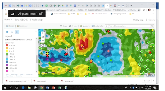
Differences shown are between Geoid12B and Geoid18. In this area one can see differences from 23 to -18 cms. Ideally, differences should be less than 5 cms for a consistent geoid model and the transformation tools. Additional GPS on BMs (and shared through OPUS) will provide more data for NGS to use in the transformation tool. Please continue these observations and submittals, the more observations we have, the better the transformation will be.
There are various resources on how and where to collect GPS on BM data. The GIS community can help with the mark recovery. OPUS requires survey grade GPS receivers. NGS has various webinars and training resources on how to make and submit the observations. Also, there is a webmap interface which shows the priority stations NGS is asking to be observed, which includes over 100 stations in Wyoming. The Rocky Mountain Region, (Joey Stone with Denver Water) has created a webmap which is derived from the NGS priority station map, and allows you to sign up for observations on a station in an effort to reduce duplicated efforts. The upkeep of this map is separate from NGS, so some cross-checking would be advised.